What is a convergence line, and why can it focus thunderstorms along the Valencian coast?
When low-level winds come together, storms can repeatedly form along a narrow strip. Spain’s Valencian coast offers a good place to see how this works.
A farmer in Central America’s Dry Corridor might measure plentiful rain in June, spend much of July waiting for the next shower, then see regular rain return later in the season. How can a dry spell fit into a rainy season? A series of weekly rainfall totals tells the story better than a date on the calendar.
Schematic seasonal cycle. The curve illustrates a pattern and has no quantitative scale.
Across parts of southern Mexico and the Pacific side of Central America, long-term averages show two particularly wet parts of the year. Rainfall often drops between them in July or August. This relative dip is known as the canícula or midsummer drought. In some places it is called the veranillo, or little summer.
Imagine two rain gauges recording the same July total. Where June and September are usually much wetter, the July figure may sit in a clear seasonal dip. At a site with a much drier July climate, that same amount has a different meaning. The local seasonal pattern supplies the context.
In midsummer, the eastern Pacific belt of tropical thunderstorms changes in strength and position. Caribbean trade winds can also strengthen. Where moist air meets the Central American mountains, it rises on the Caribbean side and favours rainfall there. Thunderstorm activity can decrease on the Pacific side of the divide. This helps explain why a single start date makes little sense across the isthmus.
Mexico also sees differences between regions and from year to year. Fewer clouds can mean stronger daytime heating. The feature used to identify the canícula is the fall in rainfall. The hottest day of the year may have occurred months earlier.
Count rainy days as well as the water they deliver. A single downpour can supply much of a week’s total, with long dry stretches on either side. To assess a particular season, compare several weeks of observations with the usual totals for the same weeks at the same location.
Compare forecast rainfall on the two sides of the Central American mountains for the same period. Then check several weeks of observations. A short forecast can show the contrast across the divide, while the observed series helps establish whether a seasonal dip has occurred.
Open the Meteorix map ↗Its timing, strength and duration vary between places and years. Individual downpours can still occur during the spell.
For official forecasts and warnings, consult your national weather service.
When low-level winds come together, storms can repeatedly form along a narrow strip. Spain’s Valencian coast offers a good place to see how this works.
Moisture from the Gulf of California and rising air along the Sierra Madre Occidental shape the summer storm season in northwestern Mexico.

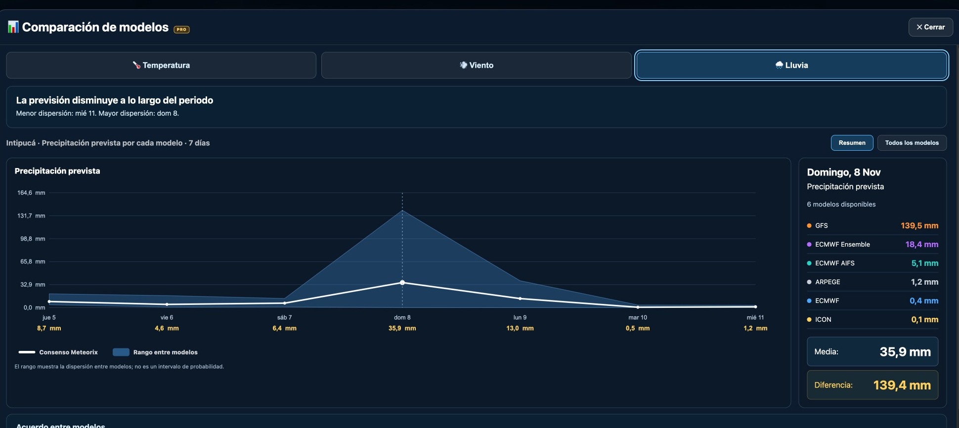
GFS forecast 139.5 mm of rain for Intipucá while several other models predicted almost none. A real Meteorix example of forecast uncertainty.
The axis of a tropical wave can cross an island in the morning and the downpours arrive hours later. To understand the timing, follow both the wind and the clouds.
Yesterday you could see a cluster of thunderstorms on satellite imagery. Today the same cluster has a label, 92L. What changed? The code tells you how forecasters are tracking the disturbance. Its intensity is a separate question.
A wind circulation can stretch across several countries between the Caribbean and the Pacific. To see which places bear the brunt of the rain, look for the river basins that one rainband after another passes over.
When a low-pressure system deepens unusually quickly, meteorologists call it explosive cyclogenesis. Learn what they measure, why latitude matters and how to track it on a pressure map.
Cloud height and shape can help you interpret a changing sky. Learn to recognise the main cloud layers and read the Meteorix cloud cover map.
Some cut-off lows pass almost unnoticed. Others help produce extraordinary rainfall. The difference depends partly on what happens below them.